Questão 1
A partir da interpretação do mapa Brasil: dimensões e pontos extremos, e
consideran...

Geography, 01.04.2021 22:20 cierra3678
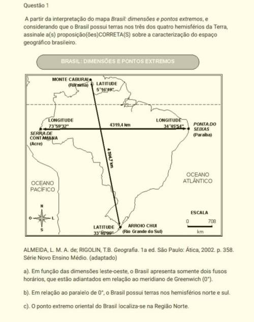
Questão 1
A partir da interpretação do mapa Brasil: dimensões e pontos extremos, e
considerando que o Brasil possui terras nos três dos quatro hemisférios da Terra,
assinale a(s) proposição(ões)CORRETA(S) sobre a caracterização do espaço
geográfico brasileiro.
ALMEIDA, L. M. A. de; RIGOLIN, T. B. Geografia. 1a ed. São Paulo: Ática, 2002. p. 358.
Série Novo Ensino Médio. (adaptado)
a). Em função das dimensões leste-oeste, o Brasil apresenta somente dois fusos
horários, que estão adiantados em relação ao meridiano de Greenwich (0°).
b). Em relação ao paralelo de 0°, o Brasil possui terras nos hemisférios norte e sul.
c). O ponto extremo oriental do Brasil localiza-se na Região Norte.
AJUDA?

Answers: 2


Other questions on the subject: Geography
Geography, 22.06.2019 08:30, culturedxnat
Which of the following countries has declared itself nuclear free
Answers: 1
Geography, 23.06.2019 02:30, mercedes73
Paraguay is one of the only two countries in the americas that don't have a coastal border. the country is slightly smaller than california. it was under a military dictatorship for 35 years, ending in 1989; today it is a constitutional republic. most of the population is roman catholic, and over 60% of the people live in cities. its environment is threatened by deforestation and water pollution. which of the following facts from the paragraph above best describes an element of paraguay's culture? (apex)
Answers: 1
You know the right answer?
Questions in other subjects:

Social Studies, 12.06.2021 14:40


Biology, 12.06.2021 14:40

Mathematics, 12.06.2021 14:40


