Mathematics, 03.01.2020 23:31 kprincess16r
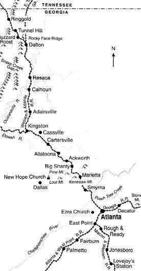
The map shows the locations of skirmishes and battles during the atlanta campaign of the civil war. if the actual distance from east point to cartersville is 52 miles, and they are 6.5 cm apart on the map, then the scale of the map is
a) 1 cm = 4 mi.
b) 1 cm = 8 mi.
c) 1 cm = 12 mi.
d) 1 cm = 16 mi.


Answers: 2


Other questions on the subject: Mathematics

Mathematics, 21.06.2019 15:50, yessijessiHaley
Name the most appropriate metric unit for each measurement
Answers: 3


Mathematics, 21.06.2019 21:00, taylordalton93
Factor the trinomial below. 12x^2 - 32x - 12 a. 4(3x+3)(x-1) b. 4(3x+1)(x-3) c. 4(3x+6)(x-2) d. 4(3x+2)(x-6)
Answers: 2

Mathematics, 21.06.2019 21:00, hongkongbrat6840
What is the length and width of a 84.5 square foot rug? will mark
Answers: 1
You know the right answer?
The map shows the locations of skirmishes and battles during the atlanta campaign of the civil war....
Questions in other subjects:


Biology, 06.12.2019 09:31


English, 06.12.2019 09:31


History, 06.12.2019 09:31


