
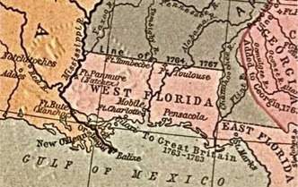
Use the map to answer the question. old map showing west florida, the panhandle, and east florida, to the southeast. under west and east florida, a label reads, to great britain, 1763 to 1783. to the left of west florida is the city of new orleans. the gulf of mexico is south. public domain based on the map, which city would be the best location for a mississippi river shipping port? a pensacola b natchitoches c new orleans d st. marks
@pheebswitch

Answers: 2


Other questions on the subject: History
History, 21.06.2019 22:00, gonzalesalexiaouv1bg
Why did reconstruction polices split the women’s suffer age movement?
Answers: 1
History, 22.06.2019 01:00, ndkjfgj4368
Develop your own point of view on whether the us should have expanded its borders. use information from the lesson and the maps to explain your opinion. give at least two reasons for your point of view and answer the following in complete sentences.
Answers: 3
History, 22.06.2019 01:30, Sillydork7853
The colonists accused king george 111 of the great britain of being a tyrant and made specific complaints against him. what were the two main complaints made against king george?
Answers: 1
History, 22.06.2019 02:20, mprjug6
Why did un coalition troops battle iraqi forces in 1991? iraq had invaded saudi arabia, along with its other border nations. iraq had invaded kuwait, which was a major source of the world's oil. the united nations wanted to remove saddam hussein from power. the united nations wanted to prevent the trade of illegal drugs.
Answers: 2
You know the right answer?
Use the map to answer the question. old map showing west florida, the panhandle, and east florida, t...
Questions in other subjects:

History, 12.10.2019 08:50

Physics, 12.10.2019 08:50

Social Studies, 12.10.2019 08:50

Social Studies, 12.10.2019 08:50

Computers and Technology, 12.10.2019 08:50


