
History, 24.03.2021 22:00 charitysamuels
Compare maps of the world in ancient times with current political maps.
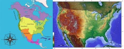
Use the maps below to answer the following question.
Image of two maps side by side. The map on the left shows a map of North America showing different cultural regions. In the south there is Mesoamerica. Above Mesoamerica is the Southwest. Along the Pacific Coast is the Pacific Northwest. Beside the Pacific Northwest and in the center of what is now the United States there is the Great Plains, Great Basin, and Plateau. On the eastern side of the continent is the Eastern Woodlands. In the North, there is the Subarctic and the Arctic. The map on the right shows a topographic map of the Unite States showing hills, mountains, grasslands, and wetlands.
Public Domain
According to these maps, the Southwest Native American cultural region was located in the United States and what other North American country?
Mexico
Canada
South America
Caribbean

Answers: 2


Other questions on the subject: History
History, 21.06.2019 16:30, 20guadalupee73248
What was one effect of nation industrialization
Answers: 3
History, 22.06.2019 03:00, thatkiddrew4063
Which statement might have been made by an anti-federalist?
Answers: 1
History, 22.06.2019 06:30, groverparham3
In the early 1800s, north africa was different from southern africa in that
Answers: 2
You know the right answer?
Compare maps of the world in ancient times with current political maps.
Use the maps below to answe...
Questions in other subjects:

Biology, 02.12.2020 06:40

English, 02.12.2020 06:40

Mathematics, 02.12.2020 06:40

Social Studies, 02.12.2020 06:40
History, 02.12.2020 06:40
Mathematics, 02.12.2020 06:40

Geography, 02.12.2020 06:40

Physics, 02.12.2020 06:40
Mathematics, 02.12.2020 06:40


