
History, 18.03.2021 02:30 joecheeramkuzhi2338
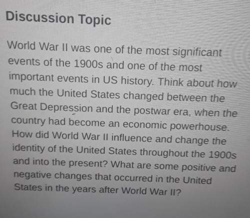
(03.03 MC)Use the map to answer the following question:
Physical map of South America, with longitude and latitude lines spanning from 100 W longitude to 15 W longitude, and 45 S latitude to 15 N latitude. Orange coloration shows Andes Mountains to the west and Brazilian Highlands to the east, as well as Guiana Highlands to the north. Amazon River Basin is shown, as well as clear views of the Pacific and Atlantic Oceans to the west and east, respectively.
© 2012 The Exploration Company
Based on this map, what can be concluded about the Inca Empire?
It was in a highlands region.
It was in a mountainous region.
It was in the Amazon Basin.
It was in North America.

Answers: 3


Other questions on the subject: History
History, 21.06.2019 21:00, alisonlebron15
From 1990 to 2008, by what percent did the world’s most developed economies cut their greenhouse gas emissions?
Answers: 2
History, 22.06.2019 01:30, lexipooh7894
How would high tariffs hurt america? a. fewer immigrants would be able to move to america b. sales of american products to other countries would go down c. americans would sell more goods to other countries d. goods imported from other countries would cost less
Answers: 1
History, 22.06.2019 05:50, cutie22327
30 in 1566 the i belonged to spain. ii rebelled against spanish rule. iii was in independent country. iv was made up of both catholic and protestant provinces.
Answers: 1
History, 22.06.2019 07:00, marleenlove3
Which of the choices below best describes columbus initial interaction with taino people
Answers: 3
You know the right answer?
(03.03 MC)Use the map to answer the following question:
Physical map of South America, with longitu...
Questions in other subjects:


Social Studies, 09.12.2021 04:50


