WILL MARK U BRAINLIEST
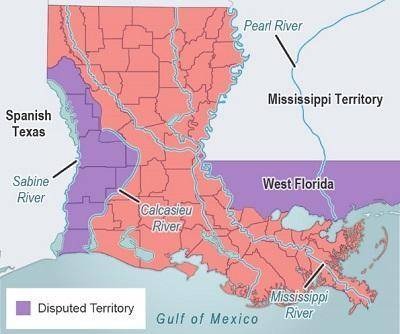
The map shows disputed territory in Louisiana during the 1810s.
...

History, 20.11.2020 21:20 jkw1222p0ttvq
WILL MARK U BRAINLIEST
The map shows disputed territory in Louisiana during the 1810s.
Which waterway officially became one of Louisiana’s borders in the Adams-Onis Treaty of 1819?
Calcasieu River
Mississippi River
Pearl River
Sabine River

Answers: 3


Other questions on the subject: History
History, 22.06.2019 11:30, debo77
Read this quotation. i challenge the warmest advocate for reconciliation to show a single advantage that this continent can reap, by being connected with great britain. . our corn will fetch its price in any market in europe. —thomas paine, common sense, 1776 one argument for independence in this quotation is that britain's taxes are too high. britain is isolating the colonies. the colonies do not need britain. britain is taking american property.
Answers: 1
History, 22.06.2019 13:30, itujggkmjf8067
What events and ideas connected to andrew jackson led to patterns of change in the united states? how did things stay the same.
Answers: 1
You know the right answer?
Questions in other subjects:
History, 05.05.2020 04:05


Arts, 05.05.2020 04:05


