
History, 10.11.2020 14:00 roblesjairus
Analyze the purposes of map projections (political, physical, special purpose) and explain the applications of various types of maps.
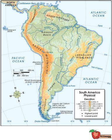
Use the map below to answer the following question:
Physical map of South America, with longitude and latitude lines spanning from 100 W longitude to 15 W longitude, and 45 S latitude to 15 N latitude. Orange coloration shows Andes Mountains to the west, and Brazilian Highlands to the east, as well as Guiana Highlands to the north. Amazon River Basin is shown, as well as clear views of the Pacific and Atlantic Oceans to the west and east, respectively.
© 2012 The Exploration Company
What question would this map be most likely to answer about the Incan civilization?
Which highlands did the Incans' enemies come from?
How many people lived at the lowest elevation point?
What physical characteristics existed in Incan territory?
How did the major rivers affect trade with the Incans?

Answers: 3


Other questions on the subject: History
History, 22.06.2019 10:30, muinat
Which statement about congress is accurate? it contains only the house of representatives. the senate’s membership is based on a state’s population. it is bicameral, according to the constitution. membership in both houses is based on equal representation.
Answers: 2
History, 22.06.2019 15:30, keaganaplin
At the munich conference, which nation “gave” the sudetenland of czechoslovakia to hitler
Answers: 2
History, 22.06.2019 19:00, paulethjara
If i could get a answer for this timeline thing that would be : ) you all!
Answers: 1
History, 22.06.2019 19:30, perezanthony2403
Where would you probably find the oldest fossils
Answers: 1
You know the right answer?
Analyze the purposes of map projections (political, physical, special purpose) and explain the appli...
Questions in other subjects:

Mathematics, 22.04.2021 01:00
Mathematics, 22.04.2021 01:00

History, 22.04.2021 01:00
Mathematics, 22.04.2021 01:00


