
History, 07.10.2020 06:01 tommyaberman
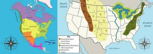
Use the maps below to answer the following question. Image of two maps side by side. The map on the left shows a map of North America showing different cultural regions. In the south there is Mesoamerica. Above Mesoamerica is the Southwest. Along the Pacific Coast is the Pacific Northwest. Beside the Pacific Northwest and in the center of what is now the United States there is the Great Plains, Great Basin, and Plateau. On the eastern side of the continent is the Eastern Woodlands. In the North, there is the Subarctic and the Arctic. The map on the right shows a map of the United States showing all states. Based on these maps, which state listed below was located in the Northeast Native American cultural region? Texas Colorado New York California

Answers: 2


Other questions on the subject: History
History, 21.06.2019 13:20, justinrojo621
How did the manhattan project to end the war? a scientists working on the project built large bombers. b scientists working on the project discovered uranium. c scientists working on the project developed the atomic bomb. d scientists working on the project shared secrets with axis scientists.
Answers: 1
History, 22.06.2019 08:30, AJSkullcrusher
Which of the following wars was the most devastating to oklahoma? a. american revolution b. mexican-american war c. civil war d. world war i
Answers: 1
History, 22.06.2019 13:20, taleiayarbough2940
Who proposed the pudding model and what does it say about the structure of the atom
Answers: 1
You know the right answer?
Use the maps below to answer the following question. Image of two maps side by side. The map on the...
Questions in other subjects:

Mathematics, 20.04.2020 13:50
History, 20.04.2020 13:50

Health, 20.04.2020 13:50

English, 20.04.2020 13:50
Mathematics, 20.04.2020 13:51

English, 20.04.2020 13:51
History, 20.04.2020 13:51


