
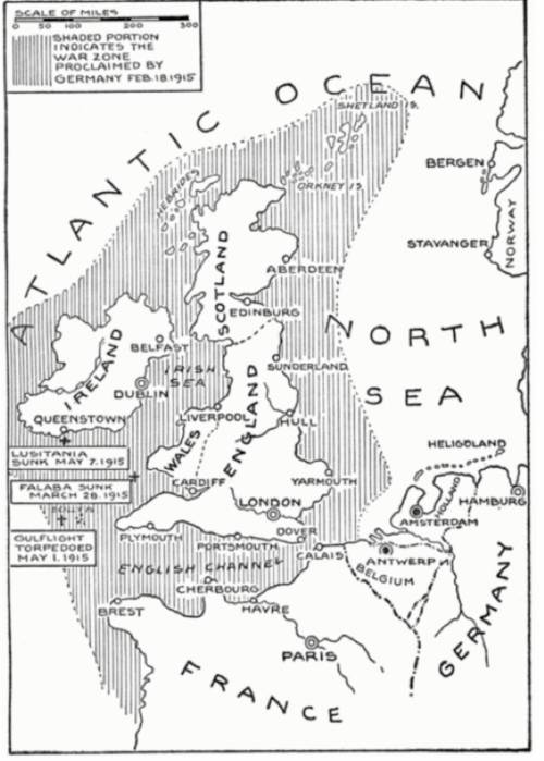
This map was published in 1919: A map image of Western Europe is shown. The map focuses on England, Scotland, and Ireland, but it shows the coast of France, Germany, and Norway. The map key notes that the shaded portion on the map indicates the war zone proclaimed by Germany on February 18, 1915. The shaded portion surrounds Ireland, Scotland, and England and extends out from the coast of France and Germany. The sinking of several ships in 1915 is noted on the map. These ships fall within the shaded portion on the map. Public Domain What does this map suggest about Germany's justification for its policy of unrestricted submarine warfare? (3 points)
A. The ships it had attacked were in the war zone.
B. The ships it had attacked were in international waters.
C. The ships it had attacked had crossed the English Channel.
D. The ships it had attacked had refused to follow wartime safe routes.

Answers: 1


Other questions on the subject: History
History, 22.06.2019 04:30, HannahJuik
Cultural appropriation and the crafting of racialized selves in american youth organization
Answers: 1
History, 22.06.2019 06:30, javonteoshamccaliste
What did afolf hitler name his german empire?
Answers: 2
History, 22.06.2019 08:30, loganhowington26
What are some ways in which the british monarchy reacted to colonists continuing to disobey british laws?
Answers: 3
You know the right answer?
This map was published in 1919: A map image of Western Europe is shown. The map focuses on England,...
Questions in other subjects:

English, 18.05.2021 20:50


Mathematics, 18.05.2021 20:50

Mathematics, 18.05.2021 20:50


