
Compare maps of the world in ancient times with current political maps. Use the maps below to answer the following question.
Compare the two maps. Which geographical feature formed the western boundary of the Plains Native American cultural region?
A) The Appalachian Mountains
B) The Rocky Mountains
C) The Mississippi River
D) The Pacific Ocean
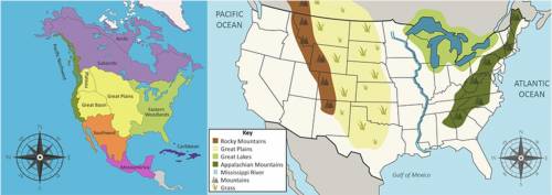

Answers: 3


Other questions on the subject: History
History, 22.06.2019 01:50, ikgopoleng8815
The system of checks and balances was designed for what purpose? fear of strong state power to keep power out of one branch to appease the southern states to allow the judicial branch to have equal power
Answers: 2
History, 22.06.2019 04:00, genyjoannerubiera
45 were the 1920s a “return to normalcy” or a “time of great change”? submit it in a letter format.
Answers: 1
You know the right answer?
Compare maps of the world in ancient times with current political maps. Use the maps below to answer...
Questions in other subjects:

Arts, 09.02.2021 17:40


Mathematics, 09.02.2021 17:40
Mathematics, 09.02.2021 17:40


