Use the physical map of Europe below to answer the following question:
A physical map of...

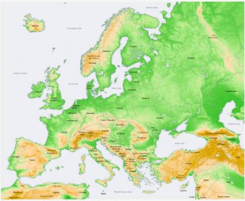
Use the physical map of Europe below to answer the following question:
A physical map of Europe showing its topography, or elevation. Areas shaded brown refer to highlands and mountains. Brown areas include most of Spain, southeastern France, northern and central Italy, Switzerland, Austria, Slovenia, Bosnia, Montenegro, Serbia, southeastern Germany, Czech Republic, Slovakia, Greece Turkey, parts of Romania, parts of Bulgaria, Iceland, Norway, and western Sweden. Green shaded areas refer to lowlands or plains. Green areas include western Portugal, coasts of Spain, most of France, United Kingdom, central and northern Germany, the western and eastern coasts of Italy, Poland, Hungary, Ukraine, parts of Romania, and parts of Bulgaria.
Creative Commons Attribution-Share Alike 3.0 Unported
In which of the following locations would you expect to find the highest population density per square mile?
The Italian coast
Central Spain
Western Russia
Northern Scandinavia

Answers: 2


Other questions on the subject: History
History, 21.06.2019 18:00, journeyhile5
How did different groups of people in france understand the enlightment ideas
Answers: 1
History, 22.06.2019 04:30, bowmanari2154
Discuss the rise and fall of westernization in japan.
Answers: 1
History, 22.06.2019 08:30, brendancrow5927
Which of the following best describes the geography of oklahoma? a. extreme elevation differences b. varied ecological regions c. limited, mountainous geography d. flat rolling hills to below sea level areas
Answers: 1
You know the right answer?
Questions in other subjects:

Mathematics, 03.12.2020 04:50

Health, 03.12.2020 04:50


Mathematics, 03.12.2020 04:50
Mathematics, 03.12.2020 04:50
English, 03.12.2020 04:50
Mathematics, 03.12.2020 04:50


