
Geography, 30.05.2021 03:20 milamdaniela
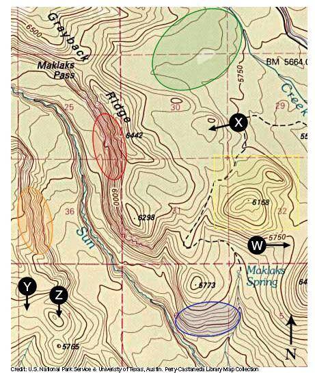
1. What is the contour interval?
2. In what direction is Maklaks Spring flowing (downstream)? How can you tell?
3. Which area is most steep of the areas enclosed in red, blue, green, or orange circles? How can you tell?
4. Imagine standing in the area in the lower-right corner of the yellow box near the "32" on the map. You would be in the east, below the higher elevation features shown in the box. From that position, looking towards the northwest (upper left corner of the box), you would see the shape or profile of those higher elevation geographical features.
5. Which graphic below best represents the profile you see?
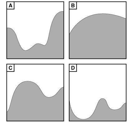

Answers: 3


Other questions on the subject: Geography
Geography, 22.06.2019 12:50, jeanlucceltrick09
5. how is transported soil different from residual soil? o a. it forms on unconsolidated materials. ob. it develops on bedrock. o c. it has been moved from another location. d. it transports other materials.
Answers: 3
Geography, 22.06.2019 16:20, wdgyvwyv8729
Amountain is larger than a hill, with steep sides true or false
Answers: 1
You know the right answer?
1. What is the contour interval?
2. In what direction is Maklaks Spring flowing (downstream)? How c...
Questions in other subjects:


Mathematics, 12.10.2019 20:50

Business, 12.10.2019 20:50

Biology, 12.10.2019 20:50
Biology, 12.10.2019 20:50
Mathematics, 12.10.2019 20:50


Social Studies, 12.10.2019 20:50


