
Geography, 15.05.2021 04:00 makayladurham19
? Question
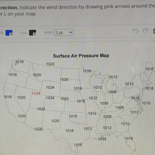
This map shows the surface air pressure across the United States. The units are rounded to the nearest
millibar. Follow the steps to complete the drawing.
Step 1: Isobars. Locate all points of 1024 millibar (mb) pressure in the northwest United States. Similar
to a dot-to-dot coloring book, use a black pen to connect all four of the 1024 mb points. Your line should
start and end at the point of 1024 mb pressure in Utah. Repeat this procedure with the next isobar
value until all the points on the map have isobars running through them. Be sure that no set of isobars
crosses another. Remember that not all isobars will be closed circles. Label each of your lines with the
last two digits of the pressure reading (24, for example).
Step 2: Air Pressure. Locate the areas of the highest and lowest pressure on your map. Label these
centers with a large blue letter H and a red letter L, respectively.
Step 3: Weather Conditions. Based on air pressure, locate the regions where you would expect to see
rain or snow and shade them in green. Then shade the regions where you would expect to see clear
skies in yellow
Step 4: Wind Direction. Indicate the wind direction by drawing pink arrows around the letter Hand
around the letter Lon your map.
WILL MARK BRA

Answers: 3


Other questions on the subject: Geography
Geography, 23.06.2019 03:00, jcrewz3628
Based on the information in the graph, what can you conclude about humans in the world in general?
Answers: 1
Geography, 23.06.2019 04:00, pandamaknae2003
What two advantages do the coastal countries of west africa have over the sahel countriesfertile soil and mineral resources temperatures and terrain human resources and natural resources weather patterns and location
Answers: 1
Geography, 23.06.2019 11:40, Spoiledgirl2905
Since 1980, which three countries have either attacked or been attacked by iraq? a. iran, turkey, united states b. iran, israel, jordan c. iran, kuwait, united states d. iran, saudi arabia, egypt
Answers: 1
Geography, 24.06.2019 06:00, nuconteaza119
True or false. epeirogenic changes deform the crust.
Answers: 1
You know the right answer?
? Question
This map shows the surface air pressure across the United States. The units are rounded...
Questions in other subjects:

Biology, 02.07.2019 17:30

History, 02.07.2019 17:30


Social Studies, 02.07.2019 17:30
Biology, 02.07.2019 17:30

Chemistry, 02.07.2019 17:30


