
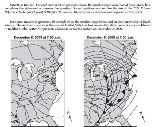
Which information shown on the weather maps best indicates that wind speeds in new york state were
greater on december 9 than on december 8?
(1) the isobars were closer together on december 9.
(2) the fronts were closer together on december 9.
(3) the air pressure over new york state was lower on december 9.
(4) the air pressure over new york state was higher on december 9.

Answers: 3


Other questions on the subject: Geography
Geography, 23.06.2019 14:00, hunterclark8422
The economies of nordon could be described a. unable to use rich resources b. struggling but diverse c. dependent on one product d. healthy and diverse
Answers: 1
You know the right answer?
Which information shown on the weather maps best indicates that wind speeds in new york state were
Questions in other subjects:


Mathematics, 21.05.2020 09:58

Social Studies, 21.05.2020 09:58

Biology, 21.05.2020 09:58

Physics, 21.05.2020 09:58
Mathematics, 21.05.2020 09:58

Health, 21.05.2020 09:58


