
Geography, 24.03.2021 22:20 TelestoisaMoon4437
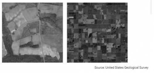
Which of the following best explains the reasons for the similarities and differences between the two land survey systems shown?'
a. Both systems set specific property boundaries for landholders. However, the metes-and-bounds system is more orderly and efficient.
b. Both systems require geometric calculations to survey property lines. However, the township-and-range system uses simplified calculation to create a more ordered landscape.
c. Both systems require geometric calculations to survey property lines. However, only properties surveyed with the metes-and-bounds system can be subdivided into smaller plots.
d. Both systems access the Global Navigational Satellite System (GNSS) to set property lines. However, GNSS is accurate only for township-and-range systems.
e. Both systems are used in the United States. However, the township-and-range survey system is used only in the eastern part of the United States.

Answers: 3


Other questions on the subject: Geography
Geography, 21.06.2019 21:10, BlehBlehBlehBleh
Number the steps from when a stimulus is received to when the body reacts
Answers: 2
Geography, 23.06.2019 11:50, niniaalvarez
Audrey planned to move from iowa to arizona. en route, she was offered a job in colorado, which she accepted. she now lives in denver, colorado, and works for an athletic apparel design company.
Answers: 1
Geography, 24.06.2019 00:30, carcon2019
Which two nations are doing the most to combat their environmental issues?
Answers: 1
You know the right answer?
Which of the following best explains the reasons for the similarities and differences between the tw...
Questions in other subjects:

Mathematics, 13.06.2021 02:20


Mathematics, 13.06.2021 02:30


