
Geography, 30.01.2021 03:00 leahmitch612
(07.01, 07.02, 07.04, 07.07 HC)
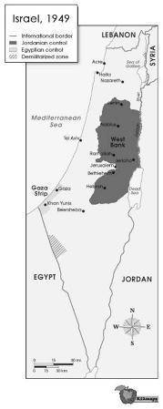
Map image showing Israeli borders and armistice lines in 1949. The map shows the state of Israel, which is bordered to the north by Lebanon, to the east by Syria and Jordan, to the south by Egypt, and to the west by Egypt and the Mediterranean Sea. The map shows that an area called the West Bank is controlled by Jordan and located in northeastern Israel. An area called the Gaza Strip is controlled by Egypt and located in western Israel along the border with the Mediterranean Sea.
© 2011 The Exploration Company
1. Discuss the evolution of the nation-state concept.
2. Based on your answer to Part A, discuss why the region shown in this map has proven so volatile. Identify at least TWO peoples who have competed to control this land, and explain why conflict over the control of territory in the above region has led to acts of terrorism.
3. Study the map above. Then answer the following questions:
a. Identify ONE type of political boundary shown on the map.
b. Explain the significance of this boundary today.

Answers: 2


Other questions on the subject: Geography
Geography, 23.06.2019 15:10, nguyendavis17
Which of the following lists shows the events in the correct order? a.)the creation of the british raj, the sepoy rebellion, gandhi’s campaign of civil disobedience, the partitioning of indiab.) gandhi’s campaign of civil disobedience, the sepoy rebellion, the creation of the british raj, the partitioning of indiac.)the sepoy rebellion, the creation of the british raj, gandhi’s campaign of civil disobedience, the partitioning of indiad.)gandhi’s campaign of civil disobedience, the creation of the british raj, the partitioning of india, the sepoy rebellion
Answers: 1
Geography, 23.06.2019 21:00, chazpooh208
All of the following are extrusive landforms except a. batholiths. b. lava plateaus. c. shield volcanoes. d. geysers.
Answers: 3
You know the right answer?
(07.01, 07.02, 07.04, 07.07 HC)
Map image showing Israeli borders and armistice lines in 1949. The...
Questions in other subjects:

Mathematics, 25.09.2020 23:01
Mathematics, 25.09.2020 23:01

English, 25.09.2020 23:01
Mathematics, 25.09.2020 23:01
Mathematics, 25.09.2020 23:01

History, 25.09.2020 23:01
Mathematics, 25.09.2020 23:01


