
Geography, 29.01.2021 19:20 Ganggang62
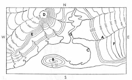
Answer the following questions using the topographic map below.
1. What is the contour interval on this map?
2. What letter represents the highest point on the map?
3. What landform is represented at letter B?
4. What direction is the river at Point A flowing?
5. What do the V-shaped contour lines represent?
6. What letters represent the two hills?
7. What letter represents a steep slope?
8. What letter represents a gentle slope?
9. What feature is represented by the letter G?
10. Calculate the elevation change between position F and C.

Answers: 2


Other questions on the subject: Geography
Geography, 23.06.2019 13:50, Theresab2021
Which of the following is a measure of the amount of light a star directly emits? a. luminosity b. wavelength c. brightness d. intensity
Answers: 3
You know the right answer?
Answer the following questions using the topographic map below.
1. What is the contour interval on...
Questions in other subjects:

English, 27.02.2021 06:10


Engineering, 27.02.2021 06:10
Chemistry, 27.02.2021 06:10


