UNITED ARAB EMIRATES
The Strait of Hormuz
Bandar Abbas
IRAN
Bandar
Lengah
Suator
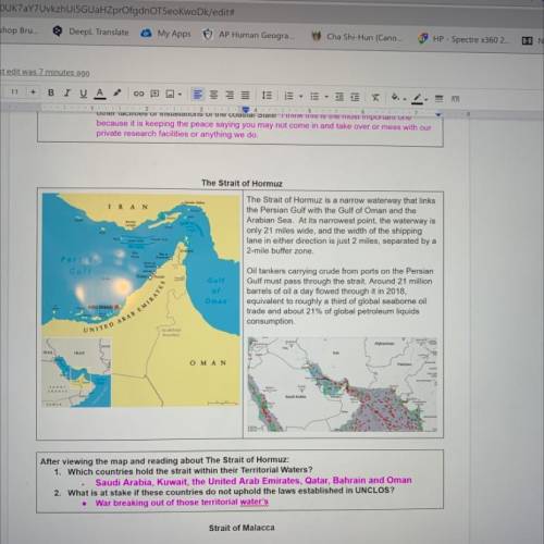
The Strait of Hormuz is a narrow waterway that links
the Persian Gulf with the Gulf of Oman and the
Arabian Sea. At its narrowest point, the waterway is
only 21 miles wide, and the width of the shipping
lane in either direction is just 2 miles, separated by a
2-mile buffer zone.
for
TOMAN
Persian
AN
Khaimah
Unal
Quwain
And
Dubai Sharjah
Com
Gulf
of
Oman
Oil tankers carrying crude from ports on the Persian
Gulf must pass through the strait. Around 21 million
barrels of oil a day flowed through it in 2018,
equivalent to roughly a third of global seaborne oil
trade and about 21% of global petroleum liquids
consumption.
ABU DHABI IN
no defined
boundary
Swam
Асн.
JAN
fade
Inc
Afghanistan
IRAQ
IRAN
Iran
Ο Μ Α Ν
PUN
Pakistan
HAREE
RAJASTHAN
SAUDI
ARABIA
Menu
Ry
OMAN
Saudi Arabia
TEMEN
GUJARAT
MAAR
After viewing the map and reading about The Strait of Hormuz:
1. Which countries hold the strait within their Territorial Waters?
Saudi Arabia, Kuwait, the United Arab Emirates, Qatar, Bahrain and Oman
2. What is at stake if these countries do not uphold the laws established in UNCLOS?
War breaking out of those territorial water's
Be in this im starting a with you so if you want you can get a partner for this. but basically im going to assign you guys a biome and you have to have a big sheet paper and you will turn it into 4 squares. the top right square is will be a drawing square for a drawing you will make of your biome. the top left square is about the biomes plants and drawings of them. the bottom left square is about the biomes animals. the bottem rights square is about the description of the biome. leave a comment or an answer and i will assign biomes. if your request one thats the one you get. send me a link to the project and i will grade ! im not a teacher btw.
The purple arrow on the map above is pointing to the an important line of latitude. a. tropic of capricorn b. equator c. international date line d. prime meridian