subject
Geography, 15.01.2021 06:20 Ashbff18

Bab el-Mandeb Strait Mecca
SAUDI ARABIA
OMAN
SUDAN
Red Sea
ERITREA
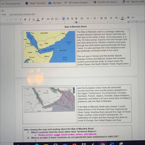
The Bab el-Mandeb strait is a strategic waterway
located between Djibouti and Yemen that links the
Red Sea to the Indian Ocean. At its narrowest, it is
only 18 miles across. Exports from the Persian Gulf
and Asia destined for Western markets must pass
through the strait before passing through the Suez
Canal. It is also perhaps the most dangerous and
geo-politically contested strait in the world.
Arabian
Sea
YEMEN
A
Gulf of Aden
Socotra Yemen
ETHIOPIA
SOMALIA
Indian
Ocean
The civil war in Yemen and the border dispute
between Eritrea and Djibouti means that constant
conflict surrounds the strait. In recent years the
United States, the North Atlantic Treaty Organization,
Epe
and the European Union have all conducted
counter-terrorism and counter-piracy operations in
the region. Furthermore, the Americans, Chinese,
Germans, French, Qataris, Emiratis, Saudi Arabians,
Japanese, and Italians all have some form of military
presence near the Bab el-Mandeb
tipus
If the Bab el-Mandeb Strait were closed, it could
keep tankers in the Persian Gulf from reaching the
Suez Canal, diverting them around the Cape of Good
Hope, another of the world's chokepoints. An
estimated 4.8 million b/d flow through this strait en
route to Europe, the United States and Asia.
After viewing the map and reading about the Bab el-Mandeb Strait:
7. Which countries hold the strait within their Territorial Waters?
Sudan, yemen, eygpt, Saudi arabia, eritrea, and djibouti
8. What is at stake if these countries do not uphold the laws established in UNCLOS?
.


Bab el-Mandeb Strait

Mecca
SAUDI ARABIA
OMAN
SUDAN
Red Sea
ERITREA
The Bab el-Mandeb strait is a

ansver
Answers: 1

Other questions on the subject: Geography

image
Geography, 22.06.2019 10:30, wfergphilly3159
In 2009, the author pawel bozyk, described brazil as a newly industrialized country. while its economy had not yet reached that of highly developed countries, brazil has moved itself into being a significant member of the international economy. what economic model does brazil fit into, regarding its development path?
Answers: 3
image
Geography, 22.06.2019 16:10, alvaradovanessa14
How many square miles is the big island of hawaii
Answers: 2
image
Geography, 23.06.2019 02:00, cerna
If the distance between two points on the ground is 10 miles and the distance between the same two points on a map is 4 inches, what is the map scale expressed as a ratio?
Answers: 1
image
Geography, 23.06.2019 11:30, dsaefong00
Which of the following can scientists estimate geologic time? a. observing rock sequences b. radiometric dating c. comparing fossils d. all of these
Answers: 1