
Geography, 21.12.2020 18:00 katherinevandehei
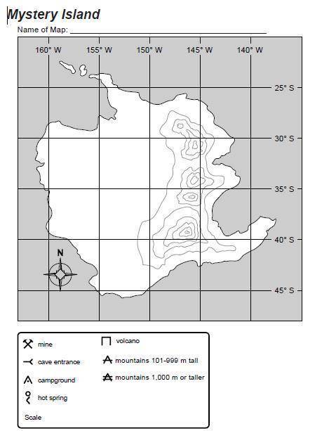
1. Aerial photographs show mountains along the east coast of the island at its highest point. The mountains range from 101 m to 2,000 m tall. Draw these mountains on the map and name them however you would like.
2. A geologist has provided information that a volcano in the mountains is extinct. This may be a great place for sightseeing. Place a volcano in the mountains. Name the volcano.
3. A river runs from the mountains at 147° W longitude, 28° S latitude and empties into a lake at 153° W longitude, 36° S latitude. The river then flows out to sea. Add the river and lake to the map and name them.
4. Field surveys show that a few flat areas along the west coast would be good for campgrounds. Draw them on the map.
5. Note that 5° of longitude or latitude equals about 563 km. Use this information and a ruler to create a scale to use with this map. Draw and label your scale next to the word Scale in the legend.
6. Select a name for this island based on its features.

Answers: 3


Other questions on the subject: Geography
Geography, 23.06.2019 17:00, jeanlucceltrick09
Seafood watch is a program that identifies sustainably harvested, ocean friendly seafood in order to
Answers: 3
Geography, 23.06.2019 21:50, natalie0908
Name the peninsula that separates the bering sea from the sea of okhotsk?
Answers: 1
Geography, 24.06.2019 05:50, sciencefanfae7248
__ has (or have) been one of the most common pull factors of migration within the united statesa. lack of humanityb. gamblingc. seafoodd. well paying jobs
Answers: 1
You know the right answer?
1. Aerial photographs show mountains along the east coast of the island at its highest point. The mo...
Questions in other subjects:

Mathematics, 24.06.2019 20:00

Social Studies, 24.06.2019 20:00

Biology, 24.06.2019 20:00
Mathematics, 24.06.2019 20:00
Mathematics, 24.06.2019 20:00


