The data presented in the map shown depict:
A-latitude in a Robinson projection
B-longitude i...

Geography, 02.11.2020 20:30 astepania0003
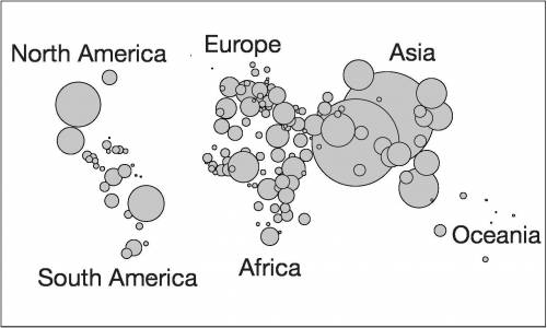
The data presented in the map shown depict:
A-latitude in a Robinson projection
B-longitude in a Mercator projection
C-population in a cartogram
D-elevation topographic map
E-taxation in a flow-line map

Answers: 2


Other questions on the subject: Geography
Geography, 22.06.2019 22:00, littlemiss114lp5woqn
The capital of australia was located a. on a south-facing harbor d. between its two largest cities g. near the great barrier reef j. close to asia
Answers: 1
Geography, 23.06.2019 23:30, mustafakhalil02
Fill in the combination notes for the main idea shown
Answers: 1
Geography, 24.06.2019 06:00, nuconteaza119
True or false. epeirogenic changes deform the crust.
Answers: 1
You know the right answer?
Questions in other subjects:

Mathematics, 01.07.2019 06:30


Biology, 01.07.2019 06:30
Mathematics, 01.07.2019 06:30

Mathematics, 01.07.2019 06:30
English, 01.07.2019 06:30
History, 01.07.2019 06:30
English, 01.07.2019 06:30


