WILL GIVE BRAINLIEST!
DAIRY FARMS IN THE UNITED STATES
Source: United States Department of Ag...

Geography, 12.10.2020 20:01 Suheily218
WILL GIVE BRAINLIEST!
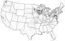
DAIRY FARMS IN THE UNITED STATES
Source: United States Department of Agriculture, Census of Agriculture, 2012
The map shows the distribution of dairy farms across the Lower 48 of the United States. Each dot on the map represents approximately ten dairy farms.
A. Identify ONE type of boundary data shown on the map.
B. Identify the region of the United States where most dairy farms are located.
C. Identify ONE spatial pattern shown on the map.
D. Describe the characteristic land use associated with the spatial pattern shown on the map.
E. Describe TWO geographic features not shown on the map that would help explain the patterns of dairy farming shown on the map.

Answers: 1


Other questions on the subject: Geography
Geography, 22.06.2019 10:30, 2020kaylahernan
Using complete sentences, outline two specific examples of how technology advances make the world seem smaller. explain what it means to say the world is “shrinking”
Answers: 1
Geography, 22.06.2019 21:00, blessing03
When you cross a time zone going east what happens to the time
Answers: 1
Geography, 23.06.2019 03:10, chloeconlon2014
Wegeners theory of continental drift states that the continents have changed throughout history while the theory of plate tectonics
Answers: 1
Geography, 24.06.2019 10:00, 22katelynfrankouqqrb
Which area is it likely to find the most population in an urban areaa rural area a suburban area
Answers: 1
You know the right answer?
Questions in other subjects:


Mathematics, 20.09.2019 22:10

Geography, 20.09.2019 22:10


