
Geography, 10.04.2020 07:23 kaitlynn73
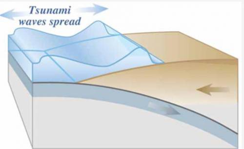
The following image represents the movement of a tsunami, a giant wave produced by an earthquake at sea. Which type of model is represented in this image?
Computer simulation
Graph
Map
Small-scale object

Answers: 1


Other questions on the subject: Geography
Geography, 23.06.2019 08:30, bbrooks9827
Dose local topography and sea surface temp contribute to differences in climate between baeious localities
Answers: 1
Geography, 24.06.2019 02:00, lclaudettecarte8346
Afathom is a unit of length, usually reserved for measuring the depth of water. a fathom is approximately 6 ft in length. take the distance from earth to the moon to be 230,000 miles, and use the given approximation to find the distance in fathoms.
Answers: 1
You know the right answer?
The following image represents the movement of a tsunami, a giant wave produced by an earthquake at...
Questions in other subjects:


Mathematics, 30.06.2019 02:40


