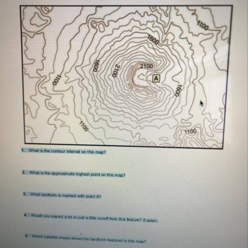
1. What is the contour interval on this map
2. What is the approximate highest point on this m...

Geography, 15.03.2020 15:38 tonehasarathi
1. What is the contour interval on this map
2. What is the approximate highest point on this map
3. What landform is marked with point A?
4. Would you expect a lot or just a little runoff from this feature? Explain.
5. Which satellite image shows the landform featured in this map 2

Answers: 2


Other questions on the subject: Geography
Geography, 23.06.2019 18:00, luffybunny
The separation of northern ireland from the republic of ireland is an example of
Answers: 1
Geography, 24.06.2019 06:30, hardyfombu
Acanyon on the ocean floor at which the crust bends downward is called a(n)
Answers: 1
Geography, 24.06.2019 14:30, mrashrafkotkaat
Ineed this right now uwu which phrases describe types of freshwater wetlands? check all that apply. flooded forest-like areas acidic areas found in northern climates grassy areas covered by shallow water areas of high elevation that feed into river systems small streams that flow into larger streams and wetlands
Answers: 1
You know the right answer?
Questions in other subjects:

Mathematics, 31.03.2020 22:43

Mathematics, 31.03.2020 22:43


Geography, 31.03.2020 22:43


