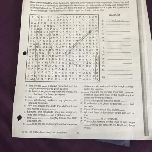
1. the latitude is always given first, and the distance north and south of the imaginary line.
...

Geography, 25.09.2019 02:00 josephjannace12
1. the latitude is always given first, and the distance north and south of the imaginary line.
longitude coordinate is given second,
called the equator
2. as lines of longitude approach the poles, the 9. lines are the vertical lines that measure
between the lines decreases.
distance east and west of the imaginary line
3. the i s 0° latitude.
called the prime meridian.
4. positioning systems may give coordi- 10. lines of longitude are also called
nates as decimals.
11. coordinates are given in degrees , and
5. any line around the earth that divides it into seconds.
two halves is a
12. lines of latitude are also called
6. latitude and longitude lines are imaginary 13. all meridians of longitude begin and end at
lines that form a o n a globe or map.
the
7. the
- roughly follows the 180° 14. the
is 0° longitude.
longitude line.
15. the circles formed by the lines of latitude get
8. lines are the horizontal lines that measure
as they get closer to the north and south
poles.

Answers: 2


Other questions on the subject: Geography
Geography, 22.06.2019 10:30, chloerodgers56
Need now! 45 points laboratory: weather map interpretation i need someone to answer the other two questions. i will give to the best answer!
Answers: 2
Geography, 22.06.2019 12:30, tasnimabdallah971
What is the y-coordinate of the point that divides thedirected line segment from j to k into a ratio of 2.3? -6-557
Answers: 1
Geography, 22.06.2019 20:00, thickness3704
Select the word from the list that best fits the definition of branch of islam that is in iran
Answers: 2
You know the right answer?
Questions in other subjects:

Mathematics, 08.02.2021 22:40


Arts, 08.02.2021 22:40
English, 08.02.2021 22:40

History, 08.02.2021 22:40
Mathematics, 08.02.2021 22:40
Mathematics, 08.02.2021 22:40


