Explanation:
Groundwater and aquifers
The Water Table: A hole dug at the beach showing the "water table" level.
A hole dug at the beach is a great way to illustrate the concept of how, below a certain depth, the ground, if it is permeable enough to hold water, is saturated with water. The upper surface of this zone of saturation is called the water table.
Credit: Howard Perlman, USGS
I hope you appreciate my spending an hour in the blazing sun to dig this hole at the beach. It is a great way to illustrate the concept of how, below a certain depth, the ground, if it is permeable enough to hold water, is saturated with water. The upper surface of this zone of saturation is called the water table. The saturated zone beneath the water table is called an aquifer, and aquifers are huge storehouses of water. What you are looking at in this picture is a "well" that exposes the water table, with an aquifer beneath it. Of course, I am cheating here, as at the beach, the level of the water table is always at the same level as the ocean, which is just below the surface of the beach.
Groundwater is one of our most valuable resources—even though you probably never see it or even realize it is there. As you may have read, most of the void spaces in the rocks below the water table are filled with water. These rocks have different porosity and permeability characteristics, which means that water does not move around the same way in all rocks below ground.
When a water-bearing rock readily transmits water to wells and springs, it is called an aquifer. Wells can be drilled into the aquifers and water can be pumped out. Precipitation eventually adds water (recharge) into the porous rock of the aquifer. The rate of recharge is not the same for all aquifers, though, and that must be considered when pumping water from a well. Pumping too much water too fast draws down the water in the aquifer and eventually causes a well to yield less and less water and even run dry. In fact, pumping your well too much can even cause your neighbor's well to run dry if you both are pumping from the same aquifer.
Visualizing groundwater
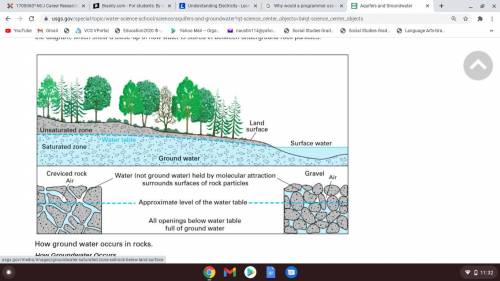
In the diagram below, you can see how the ground below the water table (the blue area) is saturated with water. The "unsaturated zone" above the water table (the gray area) still contains water (after all, plants' roots live in this area), but it is not totally saturated with water. You can see this in the two drawings at the bottom of the diagram, which show a close-up of how water is stored in between underground rock particles.